| This brief, early history of LARS was written in 1986 by Professor David Landgrebe for inclusion in a book about the history of the Purdue School of Electrical Engineering on the occasion of its 100th anniversary. |
Early Background. The successful launching of the first weather satellite, TIROS-1, on April 1, 1960 was only one of a number of indications that space technology would some day have a significant role to play in obtaining information to better manage the Earth's finite resources. Thus, about this time a number of farsighted persons and agencies began making plans for the needed research programs. This line of thinking had proceeded far enough so that in 1961 the National Academy of Science through its National Research Council formed a committee on "Aerial Survey Methods in Agriculture," chaired by Professor J. Ralph Shay, then Head of Purdue's Department of Botany and Plant Pathology.
By 1963 this committee had formulated a research program and had received Academy approval. In the process, the committee became aware of two divisions of NASA Headquarters, Bioscience and Manned Space Science, who were formulating remote sensing experiments which related to the committee plan. The committee also became aware of U.S. Army Electronics Command efforts through the University of Michigan to develop aircraft sensing equipment for military purposes; the Army agreed to support the agriculturally oriented program to the extent of making available aircraft and sensing equipment operated by the Willow Run Laboratories of U. of MI's Institute of Science and Technology. In 1964, the U.S. Department of Agriculture's Economic Research Service agreed to fund a small grant at Purdue to have data from the optical portion of the electromagnetic spectrum collected over Purdue agricultural sites by the Michigan equipment and analyzed at Purdue.[2]
Under Dr. Shay's leadership, efforts continued to bring the full program of national scale into being. In addition to those already mentioned, significant efforts were also under way at the University of California's Berkeley campus where Dr. Robert N. Colwell, a Professor of Forestry, was leading a group in developing manual photointerpretation techniques for forestry and agriculture, and at the University of Kansas, which had a substantial effort in Radar technology relative to agriculture.
As the program took form, the three universities working in the optical region, Purdue, UC/Berkeley, and Michigan, began to work in a coordinated fashion. Although all three had some effort across the full breadth of the problem, each had its area of special concentration. The Michigan effort concentrated upon building and operating an airborne data collection system. The UC/Berkeley group focused on perfecting manual data analysis schemes. Since it had both a strong engineering and a strong agricultural research capability, Purdue's focus was to be upon machine data-analysis methods and upon agricultural applications.
Dr. Shay also worked to bring together the needed resources within Purdue. He convinced Dr. Roger Hoffer, a Forestry Watershed Management graduate from Colorado State University to come to Purdue to begin the work on the USDA ERS Grant. Later Professor Roger Holmes of the EE school began to work on the engineering aspects of the problem. Then in November of 1965, Dr. Shay gave a seminar before the EE faculty to attract additional faculty to the problem. Two additional faculty, Professor K. S. Fu and Professor D. A. Landgrebe, agreed to participate at this point.
The Formation of LARS. With the arrival at Purdue of two grants, one from NASA and the other from USDA Agricultural Research Service, LARS was formally organized in January 1966 as the Laboratory for Agricultural Remote Sensing[3]. From the beginning it was envisioned as an interdisciplinary team effort, something which was, at that time, still relatively unusual on a university campus, and the only one of the three institutions working together on the program which was approaching the problem in that fashion. This approach necessarily called for a common physical location in which to conduct the research. There was no such space available on the campus, so, through the efforts of Dr. John Hancock, then Head of EE, space was obtained in Flexible Laboratory I in the Purdue Industrial Research Park.
The first eight months of the LARS was devoted to detailing the research plans for the next several years[4] and to continued gathering of the needed personnel. By the end of the Spring 1966 semester, three professional staff had been hired on a full time basis, among them, Mr. R. B. MacDonald who came to the program on temporary leave from the IBM Corp. to serve as Technical Director.[5] A second was Mr. T. L. Phillips, an MSEE recipient who began concentrating on how to deal with the large amount of data that would arise in the research effort.[6] In addition, an electronics technician, a photographic technician and 13 graduate student researchers began to work in the program.
The Approach and Methodology to be used. From an engineering standpoint, the problem before the Purdue group could be described as follows: What physical quantities should be measured with what kind of instruments, what sensitivity, resolution, precision, etc, and what approach to the analysis of the data should be used. The motivation to go to spacecraft altitudes was to enable gathering data over large land areas very rapidly and cost effectively. But, indeed, doing so would result in very large amounts of data to be analyzed. Thus the question immediately arose, couldn't the emerging computer technology be useful in some way to accomplish the needed analysis rapidly and cost effectively?
A study of the problem indicated that machine implemented pattern-recognition methods, which were rather new at that time, and developing rapidly, might be a feasible approach to machine analysis. However, applying such methods in a conventional image (i.e. picture) analysis mode would require much too fine a spatial resolution. To have spatial resolution fine enough that a machine algorithm would be able to identify plant species (e.g. by the shape of the leaf or plant) would unacceptably exacerbate the data-volume problem.
Spatial resolution is very expensive in several respects. Data volume increases as the square of the resolution, e.g. 50-meter resolution results in four times the amount of data as 100-meter resolution. In addition, as resolution is increased, the space platform stability and pointing accuracy must be increased, and so must the size (and thus the weight in orbit) of the sensor optics. Instead of relying on the spatial characteristics of the objects to be identified, it was thus decided to rely primarily upon the spectral response of the subject matter, thus creating a new type of spectroscopy. This concept was to be the central focus for LARS research for some years to come; it also became the basis for the LANDSAT series of Earth satellites and is the basis for a new generation of instruments to be carried on Space Station platforms in the 1990's.
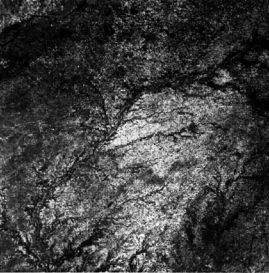
At the outset, the problem appeared to be a formidable one, given the detailed degree of information required by the user, and the high degree of variability which is present in Earth surface cover. Consider the image shown in Figure 1. This image is a Landsat image of central Indiana showing Indianapolis in the lower right and the Wabash River from the upper right to the lower left. At this resolution a human analyst, or then current machine-implemented picture processing algorithms, might have been able to locate the river, Indianapolis, and a few other features. However, the user needs were for such things as the number of hectares of wheat growing in the area and the ultimate yield from this wheat; a map of the soils of the area by soil type and any areas of soil erosion; and the mapping of the portions of the cities in the region which are devoted to commercial, industrial, high and low density housing, and the like. All of these items of information were to prove practical by spectral means within the first decade of the research at LARS.
But to make such results possible, it was clear that the work must be soundly based upon fundamental knowledge which needed to be derived, and this meant that a fundamental understanding of the spectral characteristics of Earth surface materials would be necessary. This led the plans derived during the first months of LARS to contain elements of research
The instrument research effort was necessary because spectral measurements to the precision, detail, and volume needed had never been attempted outside of the laboratory. Thus, whole new instrument concepts would be required. The same could be said for the handling and analysis of data such that new information processing concepts would also be needed. And clearly, the best of efforts would be needed from agriculturists and other Earth scientists if the whole effort was to be successful.
It is difficult to over emphasize the importance of the disciplines working together and the contribution that rapid knowledge transfer between researchers of different disciplines makes to the research progress. For many of the participants, perhaps the most stimulating aspect of LARS was to see how someone of a different discipline approaches a given problem and what is learned from a given experiment. This experience clearly proved the value of the interdisciplinary team approach, and magnified the contrast in the participants minds between true interdisciplinary research and research that is merely multidisciplinary.
Research Accomplishments.
Phase 1 1964-71. The history of the Laboratory may be divided into three identifiable phases. During the first portion of its work (1964-71) the effort was entirely of a research nature, and the Laboratory had many firsts to its credit. Some of the accomplishments during this period were:
Phase 2 1971-1982. Based upon work at LARS and the other early Earth observational research sites, a satellite series first called ERTS (Earth Resources Technology Satellite) and later renamed LANDSAT was designed beginning in 1968. As the July 1972 launch of the first of these approached, NASA decided to shift the primary emphasis of the national program from research to applications and use of the technology which had been created. Thus, in addition to continuing research activities, the second phase of the work at LARS (1971-1982) took on an added element of working more directly on demonstrations of the technology and on technology transfer techniques in order to assist private organizations and government agencies to become prepared to apply the technology[7]. This resulted in a number of additional efforts in the laboratory. Early in the program it had been determined that computational facilities were needed which provided a highly interactive environment, thus making the writing of software as well as the use of it in processing data much more efficient. Since this type of computing environment was not available on campus at that time, it had been necessary to acquire a dedicated computational facility. The first machine arrived in November 1966. It was an IBM 360 Model 44 computer, one of the first of this model delivered by IBM.
It was on this IBM 360 that LARSYS, the first software system capable of processing multispectral image data, had been created. This system continued to evolve over the years and, based upon copies given to other research labs, became the standard across the country for research labs working in the field. Revisions of it formed the basis for early software systems at Pennsylvania State University, Texas A&M University, Oregon State University, the NASA/Johnson Space Center, and a number of other sites, and a portion of it was incorporated into the Jet Propulsion Lab's VICAR system, a system for manipulating image data that had developed out of early space probes sent to the moon and planets. Through secondary distribution directly and from these early sites to many other sites, a still larger number of software systems of the field originated.
Such distribution of software was only one of many ways that the transfer of knowledge and technology generated by LARS was pursued during the second phase. During this period a set of training materials and activities were produced which were unique in the field. This wide array of training materials included an audio tape/35 mm slide minicourse series, a TV tape lecture series, a short pamphlet series, and a text book, among other things. Requests from other scientists for visits to the lab of weeks or months duration became so numerous that a formal Visiting Scientist Program was set up, with participants from around the world. Thousands of copies of the minicourses have been sold all over the world, and the textbook has gone through several printings and has been translated into several foreign languages. In addition, an annual scientific symposium was begun during this time, and a week-long short course was given periodically, reaching a frequency of once per month, for several years. Further, LARS provided training on an institution-to-institution basis on a number of occasions. For example, LARS staff provided the training for all of the analysts of the Large Area Crop Inventory Experiment (LACIE), a program conducted by NASA, NOAA, and the U.S. Department of Agriculture to test the technology in a quasi-operational wheat acreage and yield survey of the Soviet Union and several other countries based upon LANDSAT data.
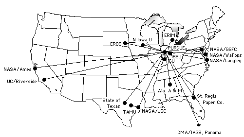
As another innovative means for exporting knowledge and technology, the LARS computer facility was upgraded in 1970 to an IBM 360 Model 67 machine. This system which was a time-shared system and was one of the larger processors available at the time was used to establish a remote terminal system, such that a potential user of the technology could try it out in an inexpensive way before needing to make a commitment to it. This system, upgraded several times, served as a major technology transfer tool throughout the second phase period and also served as the primary processing capability for LARS and a number of other research labs. A map showing sites to which there were direct leased lines is shown in Figure 2, and sites as far away as Australia used the system on a dial-up basis.
Another unique development of the laboratory was the specification, design, and acquisition of the first digitally driven, interactive image-display system. This system, originally conceived in 1966, was installed in 1969 and used until the late 1970's when more modern and less expensive versions, by then commercially available as off-the-shelf items, were acquired. This first system now resides in an IBM company museum.
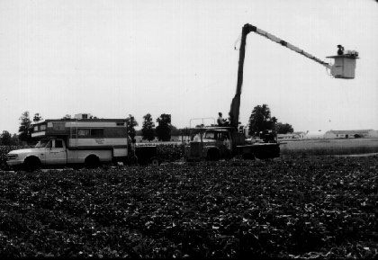
The approach and research methodology that had been adopted dictated the need for a number of unique facilities, and these continued to be evolved during the second phase period. After some experimentation with commercially available spectrometers which could be taken into the field, a new instrument was specified, designed, and contracted for. This instrument could collect a measurement of the reflectance from 0.4 um to 2.6 um sampled each 10 nm and recorded in digital form in 0.5 second, for example. The necessary supporting equipment, such as calibration panels, data logging equipment, and specially outfitted vehicles for carrying the instruments in the field were either designed and built by LARS or obtained by suitably modifying commercially available equipment. Figure 3 shows a field spectral measurement facility (circa 1975), for example. A fully equipped optically dark laboratory was constructed at LARS in which to conduct laboratory studies and from which to support operations in the field.
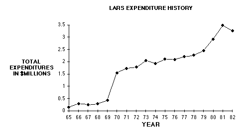
Through the years of the first two phases, LARS had a location separate from the campus, in the Purdue Industrial Research Park. LARS came in time to be a sizable unit, larger than most academic units on campus with as many as 30 faculty, 40 full time professionals, 50 graduate students and 60 or more undergraduate students. Figure 4 shows a graph of the expenditures of the Laboratory by years.
We have previously pointed out the value of pursuing a problem such as that undertaken by LARS in an interdisciplinary as compared to a multidisciplinary or unidisciplinary fashion. However, creating an environment in which researchers can and will truly work in a cooperative fashion is not often achieved, especially in a university, since by their nature, universities are organized very strongly along discipline lines. Another unique characteristic to LARS was its organizational philosophy which was evolved and which encouraged faculty, staff, and students from the various disciplines to work together. An organizational diagram showing how it was implemented is shown in Figure 5.
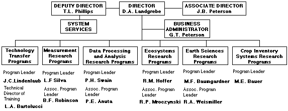
Figure 5. LARS Organization circa 1979.
Phase 3 1983-Present. Early in the 1980's the emphasis of the national program again was shifted, this time back to a research orientation. In response to this shift, the LARS staff made plans to re-orient its emphasis accordingly. At about this same time, the Purdue University Computing Center (PUCC) acquired an IBM 3083, the first IBM machine it had in many years. The availability of this machine, which was compatible with the LARS software, made it possible for the center of LARS operations to move from the Purdue Industrial Research Park back to the campus proper, thus being more conveniently available to faculty and students.
After substantial preparation, this move was finally accomplished in 1985. A new computational facility using intelligent terminals in each of the major participating departments of the campus was conceived and implemented. The intelligent terminals, which consist of personal computers suitably augmented with commercially available hardware and software, provide for the interactive portions of the processing, and the terminals are connected electronically to the PUCC where the major computation-intensive processing can be carried out. A new measurement laboratory was assembled adjacent to a vehicle garage near the Potter Engineering Center. This provides for laboratory optical experimentation as well as a convenient support facility for the field experimentation vehicles. The office staff are now located on the second floor of the Entomology Building.
Throughout its history, LARS has made many important contributions to the University and the field of remote sensing. These contributions came about through the leadership of its faculty and staff participants. A list of these leaders and their years of association is given in Appendix I. The contributions made are documented in a scientific sense in the large number of scientific publications which have resulted from the Laboratory's work. Many awards which the faculty and staff associated with it have received attest to the quality of the effort. In 1976 the Laboratory, itself, received the Pecora Award from NASA and the Department of Interior for its "contributions to the understanding of terrestrial phenomena through remote sensing techniques." However, there is perhaps no better indication of its contribution than the many advanced degree recipients who have benefited from the facilities and environment which its research programs provided. Figure 6 shows the number of these degrees by years. A list of these is contained in Appendix II and III, and a summary by department is given in Table 1.
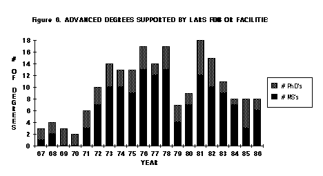
Figure 6. Number of Degrees by Years.
|
Table 1. Graduate Degrees supported by LARS, 1967-1986. |
||
|---|---|---|
| Department | Masters | PhD |
| 1 Agricultural Economics | 4 | - |
| 2 Agronomy | 22 | 13 |
| 3 Animal Science | - | 1 |
| 4 Botany & Plant Pathology | 1 | - |
| 5 Civil Engineering | 9 | 17 |
| 6 Computer Science | 16 | - |
| 7 Education | 1 | - |
| 8 Electrical Engineering | 39 | 26 |
| 9 English | 1 | - |
| 10 Forestry | 7 | 3 |
| 11 Geoscience | 18 | 3 |
| 12 Horticulture | 1 | - |
| 13 Industrial Engineering | 2 | - |
| 14 Industrial Administration | 1 | - |
| 15 Mechanical Engineering | 7 | - |
| 16 Nuclear Engineering | 3 | - |
| 17 Statistics | 6 | - |
| Total Degrees | 138 | 63 |
| Staff Member | Years of Service |
|---|---|
| P.E. Anuta | 1966-85 |
| L.A. Bartolucci | 1972-85 |
| M.E. Bauer | 1970-83 |
| M.F. Baumgardner | 1967-Present (1986) |
| J.E. Cipra | 1969-75 |
| L.M. Eisgruber | 1968-72 |
| R.M. Hoffer | 1964-Present (1986) |
| R.A. Holmes | 1965-70 |
| C.J. Johannsen | 1966-72, 85-Present (1986) |
| D.A. Landgrebe | 1966-Present (1986) |
| D.W. Levandowski | 1968-Present (1986) |
| J.C. Lindenlaub | 1970-80 |
| R.B. MacDonald | 1966-71 |
| R.P. Mroczynski | 1970-82 |
| J.B. Peterson | 1971-85 |
| T.L. Phillips | 1966-85 |
| B.F. Robinson | 1971-84 |
| J.R. Shay | 1964-66 |
| L.F. Silva | 1970-Present (1986). Dr. Silva passed away on 6/23/2018 in Homosassa, FL. |
| P.H. Swain | 1966-Present (1986) |
| R.A. Weismiller | 1971-82 |
Appendix II. PhD Degrees Granted by Purdue in Remote Sensing, 1967-86.
| Name | Field | Yr | Advisor | Thesis Title | |
|---|---|---|---|---|---|
| 1 | Cardillo, G. P. | EE | 67 | K. S. Fu | Optimum Finite Sequential Pattern Recognition |
| 2 | Rib, Harold T. | CE | 67 | Robert D. Miles | An Optimum Multisensor Approach for Detailed Engineering Soils Mapping |
| 3 | Barr, David J. | ES | 68 | Wilton N. Melhorn, R.D. Miles | Use of Side-Looking Airborne Radar Imagery for Engineering Soil Studies |
| 4 | Min, P. J. | EE | 68 | K. S. Fu | On Feature Selection in Multiclass Pattern Recognition |
| 5 | Breece, Harold T., III | EE | 69 | R. A. Holmes | Bi-directional Scattering Characteristics of Healthy, Green Soybean and Corn Leaves in Vivo |
| 6 | Johannsen, C. J. | AGR | 69 | Daniel Wiersma | The Determination of Available Soil Moisture by Remote Sensing Techniques |
| 7 | Roger, Robert E. | CE | 69 | Edward M. Mikhail | Effects of Heterogeneous Target Backgrounds on Photogrammetric Coordinate Measurements |
| 8 | Tanguay, Marc G. | CE | 69 | Robert D. Miles | Aerial Photography and Multispectral Remote Sensing for Engineering Soils Mapping |
| 9 | Helmering, Raymond J. | CE | 70 | Edward M. Mikhail | Consideration of Fundamental Problems in On-Line Computational Photogrammetry |
| 10 | Swain, Philip H. | EE | 70 | K. S. Fu | Nonparametric and Linguistic Approaches to Pattern Recognition |
| 11 | Ballew, Robert W. | CE | 71 | Edward M. Mikhail | Planitary Gravitational Fields from Orbital Photogrammetry |
| 12 | Glaser, Gary H. | CE | 71 | Edward M. Mikhail | Mensuration of Holographic Images by Photogrammetric Techniques |
| 13 | Kurtz, Maurice K., Jr. | CE | 71 | Edward M. Mikhail | Potential Uses of Holography in Photogrammetric Mapping. |
| 14 | Wacker, Arthur G. | EE | 72 | David A. Landgrebe | The Minimum Distance Approach to Classification |
| 15 | Emmert, Richard A. | EE | 72 | Clare D. McGillem | Conjugate Joint Determination for Multitemporal Data Overlay |
| 16 | Ready, Patrick J. | EE | 72 | Paul A. Wintz | Multispectral Data Compression through Transform Coding and Block Quantization |
| 17 | Brown, Kenneth E. | AS | 73 | R. C. Dobson | The Feasibility of Using a Noncontact Infrared Technique for Detecting Cattle Grubs, Hypoderma Spp. (Diptera: Oestoridae) |
| 18 | Gifford, David L. | CE | 73 | Edward M. Mikhail | Analysis of the Holographic Stereomodel and its Mensuration |
| 19 | Kumar, Ravindra | EE | 73 | LeRoy Silva, Robert Goulard | Emission and Reflection from Healthy and Stressed Natural Targets with Computer Analysis of Spectro-radiometric and Multispectral Scanner Data |
| 20 | Robertson, Thomas V. | EE | 73 | K. S. Fu, Philip H. Swain | Multispectral Image Partitioning |
| 21 | Duan, Jen-Reen | EE | 74 | Paul A. Wintz | Information-Preserving Coding for Multispectral Scanner Data |
| 22 | Riemer, Terry E. | EE | 74 | Clare D. McGillem | Optimum Constrained Image Restoration Filters |
| 23 | Wu, Chialin L. | EE | 74 | David A. Landgrebe | The Decision-Tree Approach to Classification |
| 24 | Baker, James R. | CE | 75 | Edward M. Mikhail | Geometric Analysis and Restitution of Digital Multispectral Scanner Data Arrays |
| 25 | Kettig, Robert L. | EE | 75 | David A. Landgrebe | Computer Classification of Remotely Sensed Multispectral Image Data by Extraction and Classification of Homogeneous Objects |
| 26 | Parsons, Chester L. | ES | 75 | Gerald M. Jurica | Correction of Earth Resources Technology Satellite Multispectral Scanner Data for the Effect of the Atmosphere |
| 27 | Stockton, John G. | AGR | 75 | Marvin Bauer, Marion Baumgardner | The Use of ERTS-1 Multispectral Imagery for Crop Identification in a Semi-Arid Climate |
| 28 | Bartolucci-Castedo,L. A. | FOR | 76 | Roger M. Hoffer, Donald W. Levandowski | Digital Processing of Satellite Multispectral Scanner Data for Hydrologic Application |
| 29 | Montgomery, Oscar L. | AGR | 76 | Marion F. Baumgardner | An Investigation of the Relationship between Spectral Reflectance and the Chemical, Physical and Genetic Characteristics of Soils |
| 30 | Svedlow, Martin | EE | 76 | Clare D. McGillem | Analytical and Experimental Design and Analysis of an Optimal Processor or Image Registration |
| 31 | Vanderbilt, Vern C. | EE | 76 | LeRoy F. Silva | A Laser Technique for Characterizing the Geometry of Plant Canopies |
| 32 | Ethridge, Max M. | CE | 77 | Edward M. Mikhail | Analysis of Single and Double Coverage Aircraft Multispectral Scanner Arrays for Positional Data |
| 33 | Whitsitt, Stephen J. | EE | 77 | David A. Landgrebe | Error Estimation and Separability Measure in Feature Selection for Multiclass Pattern Recognition |
| 34 | Chu, Nim-Yau | EE | 78 | Clare D. McGillem | Methods and Performance Bounds for Constrained Image Restoration |
| 35 | Hsu, Kuo-Shih | FOR | 78 | Roger M. Hoffer | The Evaluation of Landsat Data and Analysis Techniques for Mapping Tropical Forest Areas |
| 36 | Mobasseri, Bijan G. | EE | 78 | Clare D. McGillem | A Parametric Multiclass Bayes Error Estimator for the Multispectral Scanner Spatial Model Performance Evaluation |
| 37 | Wiswell, Eric R. | EE | 78 | George R. Cooper | Analytical Techniques for the Study of Some Parameters on Multispectral Scanner Systems for Remote Sensing |
| 38 | Ernst, Carola L. | FOR | 79 | Roger M. Hoffer | Digital Processing of Remotely Sensed Data for Mapping Wetland Communities |
| 39 | Stoner, Eric R. | AGR | 79 | Marion F. Baumgardner | Physicochemical, Site, and Bidirectional Reflectance Factor Characteristics of Uniformly-Moist Soils |
| 40 | Wiersma, Daniel J. | EE | 79 | David A. Landgrebe | The Analytical Design of Spectral Measurements for Multispectral Remote Sensor Systems |
| 41 | McGlone, James C. | CE | 80 | Edward M. Mikhail | Photogrammetric Analysis of Aircraft Multispectral Scanner Data |
| 42 | Unruh, John E. | CE | 80 | Edward M. Mikhail | Digital Image Simulation for Photogrammetric Applications |
| 43 | Tilton, James C. | EE | 81 | Philip H. Swain | Incorporating Spatial Context into Statistical Classification of Multidimensional Image Data |
| 44 | Batista, Getulio T. | AGR | 81 | Marvin Bauer, Marion Baumgardner | Study of Corn and Soybean Landsat MSS Data Classification Performance as a Function of Scene Characteristics |
| 45 | Kollenkark, Jeffrey C. | AGR | 81 | Thomas L. Housley, Craig S.T. Daughtry | Influence of Solar Illumination Angle and Cultural Practices on the Reflectance Properties of Soybean Canopies |
| 46 | Muasher, Marwan J. | EE | 81 | David A. Landgrebe | Multistage Classification of Multispectral Earth Observational Data: The Design Approach, Purdue University |
| 47 | Okonny, Isaac P. | ES | 81 | Donald W. Levandowski | Geologic Analysis of Remote Sensing Imagery of the Eastern Niger Delta, Nigeria |
| 48 | Seubert, Christopher E. | AGR | 81 | Marion F. Baumgardner, Craig S.T. Daughtry | A Comparison of Three Levels of Aggregation of Soil Water Information for Use in a Large Area Crop Yield Prediction Model |
| 49 | Clevenger, John W. | EE | 82 | LeRoy F. Silva | A Field Spectroradiometer for Remote Sensing Applications |
| 50 | Kalayeh, Hooshmand M. | EE | 82 | David A. Landgrebe | Classification of Remotely Sensed Image Data Using Multitype Information |
| 51 | Marshall, David S. | AGR | 82 | Greg Shaner | Epidemiology and Multispectral Sensing of Leaf Rust of Wheat |
| 52 | Setzer, Alberto W. | CE | 82 | Robert B. Jacko | The Study of Air Pollution Plumes with Imaging Techniques |
| 53 | Thurgood, Jolyon D. | CE | 82 | Edward M. Mikhail | Subpixel Mensuration of Photogrammetric Targets in Digital Images |
| 54 | Bethel, James S. | CE | 83 | Edward M. Mikhail | Surface Approximation and On-Line Quality Assessment in Digital Terrain Models |
| 55 | Ranson, Kenneth J. | AGR | 83 | Marvin E. Bauer | A Study of the Angular Reflectance Characteristics of Corn and Soybean Canopies |
| 56 | Gallo, Kevin P. | AGR | 84 | Robert F. Dale, Craig S.T. Daughtry | Interception and Absorption of Photosynthetically Active Radiation by Corn Canopies |
| 57 | Alspaugh, David H. | CE | 85 | Edward M. Mikhail | Analysis of Dynamic Terrain Profiling on Analytical Photogrammetric Systems |
| 58 | Anuta, Paul E. | EE | 85 | Clare D. McGillem | Parameter Space Techniques for Temporal Image Registration |
| 59 | Grant, Lois | AGR | 85 | Lee E. Schweitzer/ Craig S.T. Daughtry | Polarized and Non-Polarized Components of Leaf Reflectance |
| 60 | Malaret, Erick R. | EE | 85 | Clare D. McGillem | Methods of Image Restoration for Incoherent and Coherent Systems |
| 61 | Valenzuela, Carlos R. | AGR | 85 | Marion F. Baumgardner | The Element Soil as a Basic Component in a Digital Geographic Information System |
| 62 | Brooks, Christopher C. | AGR | 86 | Lee E. Schweitzer, Craig S.T. Daughtry | Light Interactions with Soybean Canopies |
| 63 | Paderes, Fidel C., Jr. | CE | 86 | Edward M. Mikhail | Geometric Modeling and Rectification of Satellite Scanner Imagery and Investigation of Related Critical Issues |
| Name | Field | Yr | Advisor | Thesis Title | |
|---|---|---|---|---|---|
| 1 | Clevenger, John W. | EE | 67 | R.A. Holmes | non-thesis option |
| 2 | Sinclair, Thomas R. | Bot.& Plant Pathology | 68 | M.M. Schreiber | Pathway of Solar Radiation through Leaves. |
| 3 | Bernstein, Danielle R. | Stat | 68 | L.J. Cote | non-thesis option |
| 4 | Scheffer, Paul A. | CS | 71 | S.D. Conte | non-thesis option |
| 5 | Robertson, Thomas V. | EE | 71 | L.L. Ogborn | non-thesis option |
| 6 | Vanderbilt, Vernon C. | EE | 71 | L.F. Silva | non-thesis option |
| 7 | Boehm, William T. | Ag Econ | 72 | M.T. Pond | An Analysis of the Effect of Employment Location on the Purchase Location Decision Made by Rural Community Residents. |
| 8 | LeBlanc, Philip N. | Agron | 72 | C.J. Johannsen, J.E. Yahner | Land Use Classification Utilizing Remote Multispectral Scanner Data and Computer Analysis Techniques. |
| 9 | Stoner, Eric R. | Agron | 72 | M.F. Baumgardner | Multispectral Determination of Vegetative Cover in Corn Crop Canopies. |
| 10 | Martin, Kenneth R. | CE | 72 | R.D. Miles | non-thesis option |
| 11 | Schricker, Don A. | CS | 72 | S.D. Conte | non-thesis option |
| 12 | Phillips, Fred | EE | 72 | L.F. Silva | non-thesis option |
| 13 | Nelson, David C. | Engl | 72 | D.M. Miller | non-thesis option |
| 14 | Schwingendorf, Susan | CS | 73 | M. Holstead | non-thesis option |
| 15 | Belcher, Edward O. | EE | 73 | W.B. Adams | non-thesis option |
| 16 | Burkhardt, Bruce W., | EE | 73 | F.J. Mowle | Design of the Necessary User Interface Hardware for Operation of the CDP-1 Mod 2 . |
| 17 | Haselby, Robert D., | EE | 73 | L.F. Silva | non-thesis option, |
| 18 | Sullivan, Thomas M., | EE | 73 | J.C. Lindenlaub | non-thesis option |
| 19 | Coggeshall, Michael E. | For | 73 | R.M. Hoffer | Basic Forest Cover Mapping Using Digitized Remote Sensor Data and Automatic Data Processing Techniques. |
| 20 | Bartolucci-Castedo, Luis | Geos | 73 | R.M. Hoffer, T.R. West | Computer-Aided Processing of Remotely Sensed Data for Temperature Mapping of Surface Water from Aircraft Altitudes, |
| 21 | Henderson, J. A., Jr. | Geos | 73 | N.M. Smith | non-thesis option, |
| 22 | Murray, William L. | Geos | 73 | G.M. Jurica | The Atmospheric Effect in Remote Sensing of Earth Surface Reflectivities. |
| 23 | Woodring, Stanley M. | Geos | 73 | T. R. West | Engineering Soils Mapping from Multispectral Remote Sensing Data Using Computer-Assisted Analysis. |
| 24 | Montgomery, Oscar | Agron | 74 | M.F. Baumgardner | The Effects of the Physical and Chemical Properties of Soils on the Spectral Reflectance of Soils. |
| 25 | Freeman, David M. | CS | 74 | W. Gautschi | non-thesis option |
| 26 | Seberger, Lewis J. | CS | 74 | P. Young | non-thesis option |
| 27 | Biehl, Larry L. | EE | 74 | L.F. Silva | non-thesis option |
| 28 | Mobasseri, Gholamreza | EE | 74 | C.D. McGillem | non-thesis option |
| 29 | Svedlow, Martin, | EE | 74 | C.D. McGillem | non-thesis option |
| 30 | Parsons, Chester L. | Geos | 74 | G.M. Jurica | Correction of Earth Resources Technology Satellite Multispectral Scanner Data for the Effect of the Atmosphere. |
| 31 | Sinnock, Scott | Geos | 74 | W.N. Melhorn | non-thesis option |
| 32 | Stohr, Christopher J. | Geos | 74 | T.R. West | Delineation of Sinkholes and the Topographic Effects on Multispectral Response. |
| 33 | Dahl, Bernard L. | Hort | 74 | T.D. Walker | An Approach to the Identification of Ecologically Sensitive Land Areas. |
| 34 | Gill, Joseph H. | Ag Econ | 75 | W. Miller | The Economic Impact of Controlling Non-Point Pollution from Cropland. |
| 35 | Beck, Robert H. | Agron | 75 | W.W. Mcfee | Spectral Characteristics of Soils Related to the Interaction of Soil Moisture, Organic Carbon, and Clay Content |
| 36 | Benson, Raymond W. | CS | 75 | P. Young | non-thesis option |
| 37 | Mapes, Kathleen S. | CS | 75 | W. Gautschi | non-thesis option |
| 38 | Singer, Michael F. | CS | 75 | P. Young | non-thesis option |
| 39 | Borger, Robert L. | Geos | 75 | D.W. Levandowski | non-thesis option |
| 40 | Frater, James B. | Geos | 75 | W.N. Melhorn | Geomorphic Interpretation of Skylab Photography Collected over the Nevada Portion of the Great Basin. |
| 41 | Kornegay, Francis C. | Geos | 75 | D.G. Vincent | Kinetic Energy Budget Analysis During the Interaction of Tropical Storm Candy, 1968 with an Extratropical Frontal System. |
| 42 | Horvath, Emilio H. | Agron | 76 | M.E. Bauer | Relation of Grain Yields and Multispectral Reflectance of Corn and Wheat. |
| 43 | Walker, Carl F. | Agron | 76 | J.E. Yahner | A Model to Estimate Corn Yields for Indiana Soils. |
| 44 | Adams, Dennis C. | CS | 76 | P. Young | non-thesis option |
| 45 | Grady, Louann M. | CS | 76 | P. Young | non-thesis option |
| 46 | Hebeisen, Cheryl D. | CS | 76 | P. Young | non-thesis option |
| 47 | Hawkins, Bob M. | EE | 76 | J.C. Lindenlaub | non-thesis option |
| 48 | Fralick, Terry N. | Geos | 76 | D.W. Levandowski | A Computer-Aided Spectral Classification of Saline Deposits, Gypsiferous Diapirs and the Totora Formation, Rio Desaguadero Region, Bolivia. |
| 49 | Jordan, Stephen G. | Geos | 76 | T.R. West | non-thesis option |
| 50 | Richardson, Graham T. | Geos | 76 | T.R. West | Environmental Geology Applied to Highway Site Selection, West Lafayette, Indiana. |
| 51 | Roepke, Harlan H. | Geos | 76 | T.R. West | non-thesis option |
| 52 | Kast, James L. | Ind. Adm. | 76 | J.C. Ullman | non-thesis option |
| 53 | Cochran, Jeffery K. | NE | 76 | R.E. Bailey | Three-Dimensional Time-Invariant Computer Simulation of Thermal Discharge as a Remote Sensing Boundary Value Problem. |
| 54 | Hixson, Marilyn M. | Stat | 76 | J. Yackel | non-thesis option |
| 55 | Sontirat, Valairat | Agron | 77 | M.F. Baumgardner | Land Use Classification of the Bangkok, Thailand Area by Digital Analysis of Landsat Multispectral Data. |
| 56 | Einselen, Kenneth L. | CE | 77 | R.D. Miles | non-thesis option |
| 57 | Selzer, Gary M. | CS | 77 | P. Young | non-thesis option |
| 58 | Bohac, Frank J., Jr. | EE | 77 | L.F. Silva | non-thesis option |
| 59 | Pomalaza, Carlos A. | EE | 77 | P.H. Swain | non-thesis option |
| 60 | Stoneburner, Ronald | EE | 77 | P.H. Swain | non-thesis option |
| 61 | Falk, Perry K. | EE | 77 | P.H. Swain | non-thesis option |
| 62 | Fleming, Michael D. | For | 77 | R.M. Hoffer | Computer-Aided Analysis Techniques for an Operational System to Map Forest Lands Utilizing Landsat MSS Data |
| 63 | Sadagopan, Sowm. | IE | 77 | A. Ravindran | On Ranking the Extreme Points of Convex Polyhedra. |
| 64 | Kardos, Christopher | NE | 77 | R.E. Bailey | The Application of Multispectral Scanner Data to the Mapping and Modeling of Power Plant Thermal Discharges in Rivers. |
| 65 | Reinhardt, John E. | NE | 77 | R.E. Bailey | The Development of a Multiport Cooling Tower Plume Model with a Sensitivity Study of Heat Transfer, Vapor Diffusion, Drag and Visibility Criteria. |
| 66 | Peterson, Carol M. | Stat | 77 | L.J. Cote | non-thesis option |
| 67 | Ahlrichs, John S. | Agron | 78 | M.E. Bauer | Relation of Crop Canopy Variables to the Multispectral Reflectance of Spring Wheat. |
| 68 | Crecelius, Don W. | Agron | 78 | M.E. Bauer | The Time of Day Effect on the Reflectance of Spring Wheat Canopies in the Four Landsat MSS Bands. |
| 69 | Hinzel, Eric J. | Agron | 78 | R.A. Weismiller | Correlation of Spectral Classes Derived from Landsat MSS Data to Soil Series and Soil Conditions for Jasper County, Indiana. |
| 70 | Kast Kaminsky , Sue A. | Agron | 78 | R.A. Weismiller, B.O. Blair | An Investigation of Analysis Techniques of Landsat MSS Data Designed to Aid the Soil Survey. |
| 71 | McMeekin, Jeffrey S. | CS | 78 | P. Young | non-thesis option |
| 72 | Kaiser, Stephen G. | EE | 78 | D.A. Landgrebe | non-thesis option |
| 73 | Kit, Edward F. | EE | 78 | P.H. Swain | non-thesis option |
| 74 | Muasher, Marwan J. | EE | 78 | D.A. Landgrebe | non-thesis option |
| 75 | Smith, Joseph F. | EE | 78 | J.C. Lindenlaub | non-thesis option |
| 76 | Sontag, Hugh D. | EE | 78 | L.F. Silva | non-thesis option |
| 77 | Burch, Randolph W. | ME | 78 | D.P. Dewitt | Thermal and Radiometric Characteristics of Wheat Canopies for Remote Sensing applications. |
| 78 | Overmeyer, Kristen M. | ME | 78 | D.P. DeWitt | Modeling the Electrical and Thermal Performance of Electrosurgical Dispersive Electrodes. |
| 79 | Traxler, Daniel V. | ME | 78 | D.P. DeWitt | non-thesis option |
| 80 | Dickman, Kenneth J. | CS | 79 | H. Schwetmann | non-thesis option |
| 81 | Crabill, Edwin F. | EE | 79 | P.H. Swain | non-thesis option |
| 82 | Nelson, Ross F. | For | 79 | R.M. Hoffer | Computer-Aided Processing of Landsat MSS Data for Classification of Forestlands. |
| 83 | McGrew, Gloria A. | Geos | 79 | D.W. Levandowski | non-thesis option |
| 84 | Walburg, Gregory | Agron | 80 | C.S.T. Daughtry | Maize Canopy Reflectance as Influenced by Nitrogen Nutrition. |
| 85 | Grogan, Timothy A. | EE | 80 | O.R. Mitchell | non-thesis option |
| 86 | Huang, Kou-Yuan | EE | 80 | C.D. McGillem, P.E. Anuta | Analytic Signal Representation in the Synthetic Seismogram of Bright Spots. |
| 87 | Smith, Bradley W. | EE | 80 | H.J. Siegel | A Multiprocessor Implementation of a Contextual Classification Image Processing Algorithm. |
| 88 | Sommers, Steven R. | EE | 80 | A.J. Koivo | non-thesis option |
| 89 | Caruso, Philip M. | ME | 80 | D.P. DeWitt | Analytic Parametric Studies of the Thermal Performance of the Gelled-Pad Electrosurgical Dispersive Electrode. |
| 90 | Swenson, Mark | Stat | 80 | D.S. Moore | non-thesis option |
| 91 | Sobeck, Joseph J. | Ag Econ | 81 | W.L. Miller | non-thesis option |
| 92 | Hinzman, Larry D. | Agron | 81 | M.E. Bauer | Influence of Nitrogen Fertilization and Leaf Rust on the Reflectance Characteristics of Winter Wheat Canopies. |
| 93 | Latz, Kathleen | Agron | 81 | R.A. Weismiller, G.E. VanScoyoc | A Study of the Spectral Reflectance of Selected Eroded Soils of Indiana in Relationship to Their Chemical and Physical Properties. |
| 94 | Henning, Thomas A. | CE | 81 | E.M. Mikhail | non-thesis option |
| 95 | Krizan, Donald L. | CE | 81 | E.M. Mikhail | non-thesis option |
| 96 | Schnabel, Mark M. | CE | 81 | E.M. Mikhail | non-thesis option |
| 97 | Golick, J. Paul | CS | 81 | H.D. Schwetman | non-thesis option |
| 98 | Azimi-Hosseini, Mani | EE | 81 | A.C. Kak | non-thesis option |
| 99 | Seed, Elizabeth C. | EE | 81 | H.J. Siegel | The Use of Database Techniques in the Implementation of Syntactic Pattern Recognition Task on a Parallel Reconfigurable Machine. |
| 100 | Stabenfeldt, M. K. | EE | 81 | L.F. Silva | The Design and Construction of a Special Purpose Data Logger. |
| 101 | Latty, Richard S. | For | 81 | R.M. Hoffer | Computer-Based Forest Cover Classification Using Multispectral Scanner Data of Different Spatial Resolutions. |
| 102 | Tsuchida, Roy K. | ME | 81 | B.M. Hillberry | A Microprocessor Based Automatic Variable Rate Intravenous Controller. |
| 103 | Haley, Mildred M. | Ag Econ | 82 | R.L. Thompson | Effective Protection in U.S. Grain Markets in the 1970s. |
| 104 | Adrien, Pierre-Marie | Agron | 82 | M.F. Baumgardner | Characteristic Variations in Reflectance of Saline and Alkaline Soils of the Bolivian Altiplano. |
| 105 | Pollara, Victor J. | Agron | 82 | C.S.T. Daughtry | An Inquiry into the Use of Spectral Data for Assessing Crop Development Stage. |
| 106 | Ward, Judy P. | Agron | 82 | C.S.T Daughtry | Effects of Management Practices on the Reflectance of Corn and Soybean Canopies. |
| 107 | Spence, Bernard L. | CE | 82 | E.M. Mikhail | non-thesis option |
| 108 | Bonsett, Tom C. | EE | 82 | A.J. Koivo | non-thesis option |
| 109 | Garrod, Susan A.R. | EE | 82 | J.C. Lindenlaub | Designing Instructional Materials for an Integrated Circuit Fabrication Laboratory Class. |
| 110 | Knowlton, Douglas J. | For | 82 | R.M. Hoffer | Evaluation of Radar Data for Forest Cover Mapping. |
| 111 | Drape, Gaylen W. | Stat | 82 | V.L. Anderson | non-thesis option |
| 112 | Luke, Eileen M. | Stat | 82 | D. Moore | non-thesis option |
| 113 | Madden, Jeffery R. | Ed. | 83 | J.D. Russell | non-thesis option |
| 114 | Al-Mahawili, S. M.H. | Agron | 83 | M.F. Baumgardner | Satellite Image Interpretation and Laboratory Spectral Reflectance Measurements of Saline and Gypsiferous Soils of West Baghdad, Iraq |
| 115 | Pazar, Steven E. | Agron | 83 | G.E. VanScoyoc | Spectral Characterization of Iron Oxide and Organic Matter in Eroded Soils. |
| 116 | Liesenfelt, Peter J. | CS | 83 | W. Gautschi | non-thesis option |
| 117 | Malaret, Erick R. | EE | 83 | D. A. Landgrebe | Noise in Earth Observational Sensor Systems. |
| 118 | Pickett, James K. | EE | 83 | Confidential | |
| 119 | Dean, Martha Ellen | For | 83 | R. M. Hoffer | Evaluation of Thematic Mapper Simulator Data for Computer-Based Forest Cover Classification. |
| 120 | Accame, Guillermo M. | Geos | 83 | H.O.A. Meyer | Mineralogical, Trace-Element and Landsat Multispectral Evaluation of Gossans in the Alma Mining District, Colorado. |
| 121 | Pavey, Richard R. | Geos | 83 | W.N. Melhorn | Late Wisconsinan Till Stratigraphy in West-Central Indiana. |
| 122 | Valdes-Altamira, J. A. | Agron | 84 | M.F. Baumgardner | Assessment of TM Thermal Infrared Band Contribution in Land Cover/Land Use Multispectral Classification. |
| 123 | Taylor, Stephen D. | CE | 84 | R.D. Miles | non-thesis option |
| 124 | Davallou, Farzin | EE | 84 | O.R. Mitchell | Recognition of Three Dimensional Objects from a Random Viewing Angle. |
| 125 | Kessler, Joel R. | EE | 84 | G.W. Neudeck | non-thesis option |
| 126 | Rappaport, T. S. | EE | 84 | C.D. McGillem | The Design and Development of a Mobile Robot Location System. |
| 127 | Lozano-Garcia, D. F. | For | 84 | R.M. Hoffer | Multitemporal Analysis of Multispectral Scanner Data - a Comparison of Three Classification Approaches. |
| 128 | York, James D. | ME | 84 | J. Modrey | Mechanics of a Two Axes Passive Precision Level Monitor for Machine Tools. |
| 129 | de Venecia, Kurt J. | CE | 85 | E.M. Mikhail | non-thesis option |
| 130 | Mundy, Stephen A. | CE | 85 | G.W. Marks | non-thesis option |
| 131 | Mussman, David E. | EE | 85 | P.H. Swain | Short-Term Effects of Soman on the Electro- encephalogram of Baboons. |
| 132 | Nash, Lou M. | Agron | 86 | C.S.T. Daughtry | The Effects of Cultural Practices on the Spectral Response of Maize. |
| 133 | Padron, Luis R. | Agron | 86 | C.J. Johannsen, M.F. Baumgardner | non-thesis option |
| 134 | Molino, Dan L. | EE | 86 | E.J. Delp | non-thesis option |
| 135 | Poland, Thomas F. | EE | 86 | C.D. McGillem | non-thesis option |
| 136 | Kenaga, Steven G. | Geos | 86 | W.N. Melhorn | Refined Interlobate Stratigraphy of West-Central Indiana and Other Tales of the Pleistocene. |
| 137 | Struble, Michael L. | IE | 86 | J.I. Elgomayel | non-thesis option |
[2] R.M. Hoffer Interpretation of Remote Multispectral Imagery of Agricultural Crops (Later known as LARS Annual Report No. 1) Purdue University Agricultural Experiment Station Bulletin No. 831, July 1967.
[3] The name of the Laboratory was changed to Laboratory for Applications of Remote Sensing when in 1969 the Laboratory was funded by NASA to extend its work to include Geology, Hydrology, and Geography in addition to Agriculture.
[4] Remote Multispectral Sensing in Agriculture LARS Annual Report Vol. 2. Purdue University Agricultural Experiment Station Bulletin No. 832, July 1967.
[5] Mr. MacDonald remained in that position until 1971 when he resigned from the University to accept a position in the field of remote sensing in NASA.
[6] Mr. Phillips remained with LARS until 1985 eventually rising to the position of Deputy Director of LARS.
[7] Actually, the importance of technology transfer had already been recognized, and a Technology Transfer Program Area had become a formal part of the Laboratory organization in the late 1960's.